



Shabelle River nears flood-risk level at Jowhar as heavy rains forecast across Somalia
 0
0
- Visits: 164
-

- Share
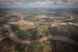

The Shabelle River has risen sharply at Jowhar and is approaching flood-risk levels as moderate to heavy rains are forecast across parts of Somalia and the Ethiopian highlands that feed the country’s two main rivers, according to the latest FAO-SWALIM weather outlook.
The river at Jowhar rose from 2.48 meters to 4.70 meters over the past week, an increase of 2.22 meters, according to the Somalia Water and Land Information Management weekly forecast covering Oct. 7-13.
The pace of the rise has slowed, however, from about half a meter on Oct. 4 to 20 centimeters on Oct. 7, according to the report.
The increase comes as Somalia enters the October-to-December Deyr rainy season under heightened concern about El Niño-related flooding. FAO warned last month that some parts of central and southern Somalia have as much as a 90% probability of receiving above-normal seasonal rainfall, with the Juba and Shabelle river basins among the areas of particular concern.
FAO-SWALIM’s latest forecast, based on the U.S. National Oceanic and Atmospheric Administration’s Global Forecast System model, projects moderate to heavy rainfall over much of Somaliland, Bay, Bakool and Hiiraan, as well as inland central Somalia.
Heavy rainfall is also expected in parts of the Ethiopian highlands, an important development because rainfall upstream can raise the Juba and Shabelle rivers in Somalia even when local rainfall is limited.
FAO has previously cautioned that flood waves generated by heavy rain in Ethiopia can reach Somalia later and urged authorities and humanitarian groups to monitor both upstream rainfall and river levels closely.
Along the Shabelle, levels at other monitoring stations remained well below flood thresholds.
At Belet Weyne, the river stood at 4 meters after reaching 4.16 meters on Oct. 3 and falling to 3.78 meters two days later. The latest reading is 2.50 meters below the moderate flood-risk threshold of 6.50 meters.
The level is also 1.90 meters lower than on the same date last year and about half a meter below the long-term average for early October.
Upstream at Deefow, the river remained broadly stable at 2.70 meters, compared with 2.73 meters a week earlier. It was 3.80 meters below the moderate flood threshold.
Bulo Burti recorded a more pronounced increase, rising 62 centimeters during the week to 3.20 meters, though it remained 3.30 meters below the moderate flood-risk level.
Conditions along the Juba River were comparatively stable.
At Dollow, the river rose from 2.54 meters to 2.64 meters during the week and remained 1.86 meters below its moderate flood threshold of 4.50 meters.
At Luuq, levels were virtually unchanged, increasing from 2.34 meters to 2.36 meters and remaining more than 3 meters below the moderate flood-risk mark.
Rainfall has already begun earlier than usual in some areas.
Bardhere in Gedo recorded 93 millimeters of rain during the first five days of October, while Galkayo received 50 millimeters, with both locations exceeding their normal rainfall totals for the entire month within those first five days, according to SWALIM.
The rainfall pattern has been highly uneven, however. Rains extended from eastern Gedo through Bay, Bakool and Hiiraan into central Somalia, while much of the Juba valley, Lower Juba and coastal areas of Lower Shabelle remained largely dry.
Light to moderate rain is forecast this week in parts of Bay and Gedo and along coastal Lower Juba. Middle Juba, inland Lower Juba and some parts of Lower Shabelle are expected to receive little rainfall.
The heightened monitoring follows warnings that the 2026 Deyr season could produce significant flooding if strong El Niño conditions combine with above-normal rainfall.
FAO has pointed to 1997 and 2023 as years with similar climate conditions, while stressing that they are not predictions of what will happen this season. Both years brought severe flooding to Somalia.
In 2023, floods caused widespread displacement, damaged infrastructure and destroyed crops and livestock. The 1997 floods killed more than 2,300 people, according to historical data cited by FAO.
Authorities and humanitarian organizations have been urged to use current forecasts to reinforce river embankments, prepare evacuation routes, identify safe areas and position emergency supplies before river levels reach dangerous thresholds.

Christina Goldbaum/IRIN
SOURCE:-HOL.COM






 Facebook
 Twitter
 Youtube
 Google+
 RSS Feed
Shabelle River nears flood-risk level at Jowhar as heavy rains forecast across Somalia
.